GFED5 Gridded Files
NetCDF4 files containing gridded estimates of burned area and emissions can be downloaded via SFTP. Login details are available here (note that the port number is 1022).
- GFED5.1 — data for 1997–2022 (see accompanying README for details)
- GFED5.1NRT — near‑real‑time data for 2023 onward, divided into reprocessed and update directories
- Ancillary — summary tables, input datasets, and code used for GFED5 publications
Trace gas and aerosol species include carbon (C), dry matter (DM), CO₂, CO, CH₄, NMOC (gaseous), H₂, NOₓ (as NO), N₂O, PM2.5, TPC, OC, BC, SO₂, NH₃, C₂H₆, CH₃OH, C₂H₅OH, C₃H₈, C₂H₂, C₂H₄, C₃H₆, C₅H₈, C₁₀H₁₆, C₇H₈, C₆H₆, C₈H₁₀, toluene lump, higher alkenes, higher alkanes, CH₂O, C₂H₄O, C₃H₆O, C₂H₆S, HCN, HCOOH, CH₃COOH, MEK, CH₃COCHO, and HOCH₂CHO. Additional species can be computed on request.
Summary Tables
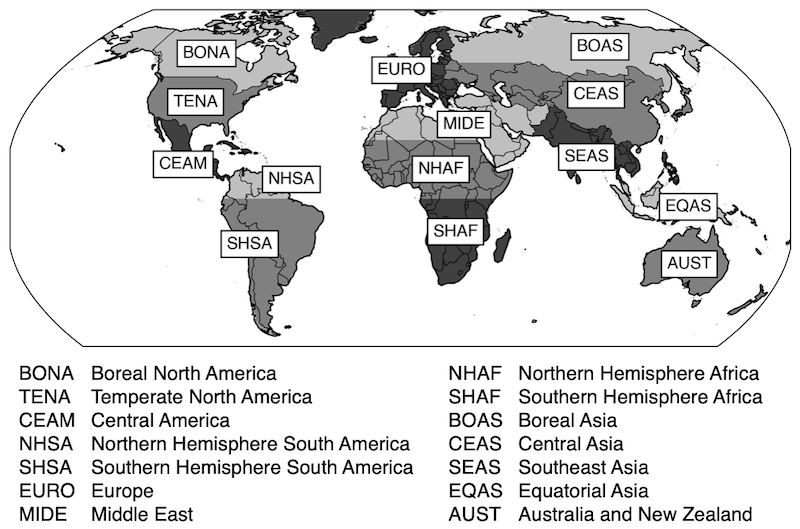
Summary tables for global and regional emission estimates from 1997 onward are available here. Regional estimates are based on the 14 basis regions shown below, using the abbreviations listed in the tables.
Related Datasets
GFED4
GFED4s was released in 2017 and described in van der Werf et al. (2017). It was the first GFED version to include small‑fire burned area, using the statistical approach introduced in Randerson et al. (2012).
After 2016, emissions are no longer based on burned area due to changes in MODIS burned‑area collections. GFED4s used Collection 5.1, which was superseded by Collection 6. Emissions for the post‑2016 period are derived from MODIS active‑fire detections and a grid‑cell‑specific conversion calibrated using the 2003–2016 overlap period.
GFED4s covers 1997–2025 at 0.25° spatial resolution. We recommend using GFED5 when possible.
GFED 500‑meter
Although GFED spatial resolution has increased over successive versions, it remains coarser (0.25°) than the satellite data used (mostly 500 m). To better align model and data resolution, a simplified GFED model was run at 500‑meter resolution for the 2002 onward period, described in Van Wees et al. (2022).
GFED5 is not provided at 500‑meter resolution because the small‑fire burned‑area algorithm requires spatial aggregation. GFED500m offers greater spatial detail, whereas GFED5 includes small‑fire burned area and is available in near real time.
Historic Emissions (BB4CMIP)
Fire emissions prior to the satellite era are uncertain, but proxy data and modeling help characterize variability and trends. The BB4CMIP dataset, described in Van Marle et al. (2017), was constructed for CMIP6 using GFED4s as an anchor dataset.
Ongoing efforts aim to harmonize BB4CMIP with GFED5 and update the dataset.